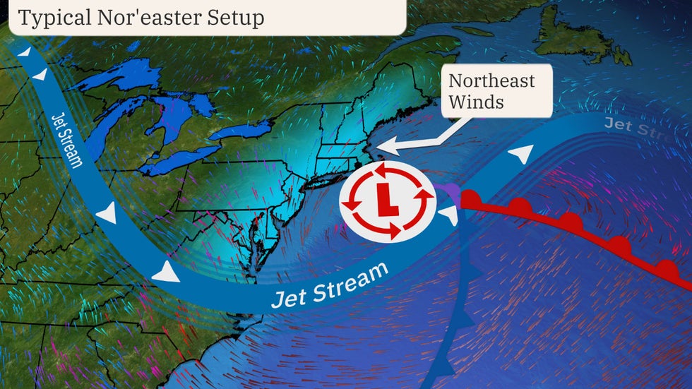
A nor’easter is a strong area of low pressure along the East Coast of the United States that typically features winds from the northeast off the Atlantic Ocean – hence the term “nor’easter.”
The heavily-populated Interstate 95 Northeast Megalopolis, including Boston, New York City, Philadelphia and Washington D.C., is especially vulnerable to this type of storm due to the proximity to the coast.
A nor’easter may bring heavy rain or snow, strong winds, coastal flooding and rough seas to the affected areas. They may also bring severe weather to parts of the South.
Nor’easter Fast Facts:
- Snow isn’t a requirement for a nor’easter. It’s all about the wind! As long as winds are coming out of the northeast, a system can be called a nor’easter, but most gain the moniker when strong winter storms crawl up the Northeast coast.
- These storms are most frequent and strongest between September and April, but can occur any time of the year.
- They typically develop between Georgia and New Jersey within 100 miles east or west of the East Coast.
- They move east or northeastward.
- They’re often at maximum intensity near New England or Canada’s Maritime Provinces.
Here’s how these storms develop:
Their formation and intensity are much about temperature contrasts, but also location, location, location.
A difference in temperature between the warm air over the water and cold air over land provides the instability and energy needed to develop and fuel nor’easters.
The warmth comes from the warm waters of the Gulf Stream – a warm, swift Atlantic Ocean current that originates in the Gulf of Mexico, stretches to the tip of Florida and follows the United States’ eastern coastline northward before crossing the Atlantic. This helps keep the coastal waters relatively mild through the winter, which acts to warm the cold air above the ocean water and lifts air particles.
The cold air comes with some help from the polar jet stream, which transports cold air southward out of Canada into the U.S., then eastward toward the Atlantic Ocean.
This setup makes the U.S. East Coast an ideal spot for nor’easters, especially during the winter months. But they wouldn’t be as strong with just these temperature contrasts.
Storm systems often develop in the “lee,” or the downwind side, of the Appalachians, so nor’easters are often intensifying along the East Coast while also feeding off of the temperature contrasts.
Common Nor’easter Tracks:
There are a couple of ways nor’easters can develop.
The first type develops primarily along the Gulf Coast or East Coast and tracks northeastward up the coast. This is considered a “classic” nor’easter and referred to as a “Miller Type-A” storm.
The second type originates in the Midwest and slides eastward toward the Appalachians. Once it hits the mountains, the storm loses its coherent low-pressure center, but the low redevelops along the East Coast and rides up the coast as a classic nor’easter would do. This is referred to as a “Miller Type-B” storm.
If a nor’easter threatens your town, be sure to take the proper steps to prepare. This includes stocking up with at least three days of food, water and other necessary provisions, as you may be left without power for multiple days due to strong winds potentially knocking down trees and power lines.
If roads become snow-covered or flooded, stay off them until they are plowed or flooding subsides. It is best to stay home until the storm passes. Conditions can change quickly and you don’t want to be stranded on an unsafe road, unable to get home.
Source: https://www.wunderground.com/article/science/weather-explainers/news/2024-01-02-what-is-a-noreaster


