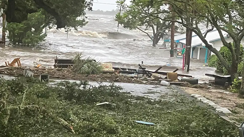
(9:17 a.m. ET) Over 6 Feet Of Water At Cedar Key Tide Station
The National Oceanic and Atmospheric Administration (NOAA) tide station observed water levels in Cedar Key, Florida, at over six feet the predicted high tide and still rising into the “major flooding” category.
(9:10 a.m. ET) Florida Power Outages Top 215,000
More than 215,000 customers were without power in Florida as of 9 a.m. Wednesday morning. Wakula, Taylor, Lafayette, Suwannee and Dixie counties had the highest concentrations of outages, according to PowerOutage.com.
(8:50 a.m. ET) Steinhatchee Businesses, Roads Underwater
Steinhatchee, Florida is experiencing extreme flooding from Idalia’s storm surge. Video from Stag Harbor Marina shows buildings and roads overtaken by water, with debris and broken wood floating in toward town.
Water levels were near the roof lines of some businesses, including Roy’s Restaurant and Crabbie Dad’s Bar & Spirits.
(8:45 a.m. ET) Flooded Roads, Mobile Home Park In Pasco
Pasco’s Sheriff’s Office tweeted warnings to residents as the city saw flooding encroaching on homes, downed trees and downed power lines.
The sheriff’s office urged people to stay off of roadways and to consider turning off their electricity if their home is experiencing flooding.
(8:35 a.m. ET) Huge Tree Limbs Crash Down On Live TV
Reynolds Wolf of The Weather Channel was live on air as huge live oak tree branches crashed into a yard while he sheltered under a home’s outdoor canopy.
“This is incomprehensible what we’ve seen happen here over the last half-hour,” he said while looking out over the yard littered with large fallen tree branches.
(8:20 a.m. ET) Storm Surge Flooding Pours Ashore In Steinhatchee
Along the Big Bend, new video from Steinhatchee, Florida, showed severe flooding in coastal areas as storm surge pushed farther inland.
(8:10 a.m. ET) Restrict Water Usage, Clearwater Officials Tell Residents
“For those who have chosen to remain on the beaches despite the mandatory evacuation order, please restrict your water and toilet usage. Due to flooding, the city’s lift stations and stormwater system are under strain,” the City of Clearwater said in a post on X, formerly known as Twitter.
(7:45 a.m. ET) Landfall Has Occurred
The National Hurricane Center said Idalia made landfall at 7:45 a.m. ET near Keaton Beach with maximum sustained winds of 125 mph, a high-end Category 3 hurricane. It is the eighth major hurricane to make landfall along the Gulf Coast since 2017.
(7:40 a.m. ET) Resetting The Scene Across Florida
Things are moving quickly now, so here is the latest as the situation worsens in several areas:
-Wakulla County has suspended emergency operations and won’t respond to calls until conditions allow them to do so safely.
-Several boats were damaged or sank in the Marina Jack Yacht Basin in Sarasota, according to the Sarasota Police Department. “DO NOT travel to the barrier islands. Conditions expected to worsen,” the department also said.
-Outages have soared to more than 130,000 customers statewide, according to PowerOutage.us.
-Idalia has dropped back to a Category 3 hurricane as it undergoes an eyewall replacement cycle near landfall, but expected impacts have not changed.
(7:15 a.m. ET) Cantore Documents Major Storm Surge Flooding In Cedar Key
The Weather Channel storm tracker Jim Cantore is seeing feet of storm surge pushing through the street in Cedar Key, Florida.
“We’re almost at the level that we were with Hermine in 2016,” he said, referring to the record 6 feet of storm surge that was recorded with Hurricane Hermine. Storm surge is expected to push water levels even higher in the coming hours.
(6:55 a.m. ET) ‘TAKE IMMEDIATE SHELTER’
As the extreme wind warning was issued, the National Weather Service in Tallahassee did not mince words in any way whatsoever:
“TAKE IMMEDIATE SHELTER along the coast of Taylor and Dixie County. Eyewall of Hurricane Idalia will be coming onshore in the next 1-2 hours. THIS IS AN EXTREMELY DANGEROUS AND LIFE THREATENING SITUATION!”
(6:30 a.m. ET) What Our Experts Want You To Know
Weather.com senior meteorologist Chris Dolce shared these thoughts as we get closer to Idalia’s landfall:
-Idalia intensifying into a Category 4 means wind damage could be devastating to catastrophic near a small area where the center makes landfall on the coast and for tens of miles inland.
-Landfall of that center should happen in the next couple of hours.
-Storm surge is rising along the coast with Cedar Key seeing 5 to 6 feet of surge as of 6 a.m. EDT. Surge will only continue to rise as landfill happens.
(6:10 a.m. ET) Extreme Wind Warning Issued
The National Weather Service in Tallahassee has issued an extreme wind warning for Steinhatchee, Horseshoe Beach and Dekle Beach along the Gulf Coast. This type of warning indicates the eyewall of a hurricane is coming ashore and is typically reserved for wind speeds of at least 115 mph.
(5:45 a.m. ET) Notable Wind Gusts In Florida So Far
-70 mph: Sarasota
-58 mph: Tampa
-58 mph: St. Petersburg
(5:30 a.m. ET) Here’s Where Cantore Is Riding Out The Storm
The Weather Channel storm tracker Jim Cantore resumed his live updates from Cedar Key, Florida, at 5 a.m. As the water rose, Cantore retreated from the road to safe shelter to continue his reports.
You can see his first live report of the morning here.
(5:20 a.m. ET) Outages Top 50,000 In Florida
According to PowerOutage.us, more than 50,000 Florida homes and businesses are now without power due to the storm. Nearly half of those outages are in Pinellas County, but the largest percentage of customers in the dark are in counties along the Big Bend.
Outages are expected to climb rapidly as the day goes on, and in some areas, it could be days before power crews are able to get up in the air to make repairs.
(5 a.m. ET) Idalia Now A Category 4 Hurricane; New Advisories Issued For East Coast
Hurricane Idalia has rapidly intensified to a Category 4 hurricane with maximum sustained winds of 130 mph just hours before landfall along Florida’s Big Bend, the National Hurricane Center said in its latest advisory.
Additionally, hurricane warnings have been issued for parts of the East Coast. Here’s what has changed:
-Hurricane warning issued for the East Coast of the United States from Altamaha Sound, Georgia, to Edisto Beach, South Carolina.
-Storm surge warning issued from St. Catherine’s Sound, Georgia, to the South Santee River, South Carolina.
-Tropical storm warning issued from north of Surf City, North Carolina, to the North Carolina/Virginia border, and Pamlico and Albemarle sounds.
-The tropical storm warning for the west coast of Florida from Bonita Beach southward is discontinued.
(4:45 a.m. ET) Water Overtakes Roads In Madeira Beach
West of St. Petersburg, the barrier island community of Madeira Beach was reporting serious flooding with water over many roads as Idalia piled up water along the coastline. Local reporter Chad K. Mills was documenting the impacts.
Mills also reported that there was a condominium fire in the area, but emergency managers said nobody was hurt.
(4:30 a.m. ET) Serious Flooding Ongoing In Tampa-St. Petersburg Area
Storm chaser Brandon Clement documented serious flooding near Tampa and St. Petersburg as Idalia pushed huge amounts of water onshore this morning.
(4 a.m. ET) Key Bridges Close In Tampa Area
Both the Sunshine Skyway and Howard Frankland bridges were closed early this morning as Idalia’s winds intensified in the Tampa-St. Petersburg area, the Hillsborough County Sheriff’s Office announced.
Source: https://weather.com/safety/hurricane/news/2023-08-30-hurricane-idalia-live-updates-blog-florida-landfall?cm_ven=hp-slot-1


