While the Atlantic Basin continues its hurricane season slumber, a pair of Pacific systems, Hurricane Dora and the remnants of Tropical Storm Eugene, are interesting in several aspects.
An abundance of dry, sinking air is currently keeping the lid on development in the tropical Atlantic Basin, despite record warm ocean water for this time of year.
So, let’s touch on a pair of Pacific systems with some intriguing facets.
Hurricane Dora wasn’t a typical Pacific storm. Tropical Depression Five-E formed on July 31 a few hundred miles off Mexico’s Pacific Coast. It rapidly intensified into Hurricane Dora the following day, and eventually reached Category 4 intensity.
As we discussed earlier this season with Hurricane Calvin, most hurricanes from the Eastern Pacific Basin weaken when they enter the Central Pacific Ocean.
That’s because ocean currents usually bring cooler water southward off the California coast, then southwestward to an area of the basin east of Hawaii. It’s also because there’s usually more dry, sinking, stable air in that area. Wind shear that can weaken and rip apart hurricanes and tropical storms also usually increases closer to Hawaii.
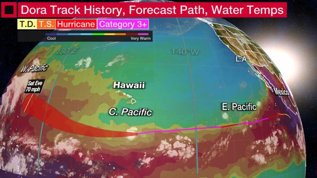
However, Dora tracked farther south than Calvin. That kept it over warmer ocean water, as you can see in the map below, and also avoided typically stronger wind shear it would have had earlier.
Also, when Dora reached Cat. 4 intensity, its structure became what’s known as an annular hurricane. That means it has a ring of strong convection completely surrounding its eye, but few or no outer rainbands, taking on the appearance of a truck tire or doughnut.
That’s important because annular tropical cyclones can wall off the negative factors such as dry air or wind shear longer. They tend to weaken slower than more conventional tropical cyclones.
Dora has already traveled over 3,000 miles since it was first dubbed it T.D. Five-E.
The latest forecast from the Central Pacific Hurricane Center suggests Dora could last into late week or this weekend, if its annular structure can ward off those negative factors, despite its small size.
Its long voyage is unusual. As you can see in the map above, Dora’s track could extend another 2,000 miles, possibly as far as the International Date Line.
That would mean Dora would have tracked through the Eastern Pacific (east of 140 degrees West longitude), Central Pacific (from 140 degrees West to the International Date Line) and Western Pacific Basins (west of the International Date Line).
That feat is pretty rare.
Five years ago, Hurricane Hector maintained hurricane strength in both the Eastern and Central Pacific basins, before crossing the International Date Line as a tropical storm.
Ironically, another “Hurricane Dora” in August 1999 accomplished that same thing as Hector, but barely missed crossing the date line as a hurricane.
The king of Pacific long-lasting tropical cyclones, though, was John in 1994. Over 31 days, John traveled 8,189 miles over all three Pacific basins. That’s more than double the distance between Tampa, Florida, and America’s northernmost city, Utqiagvik – formerly known as Barrow – in Alaska.
Once John crossed the International Date Line, it became known as as typhoon, what hurricanes are called in the Western Pacific Basin. After that it stalled, executed a hairpin loop while weakening, then tracked northeast back over the date line to become Hurricane John once again.
It will have indirect impacts in Hawaii. Dora is passing well south of Hawaii and is no direct threat.
But there are some things going on in the islands that wouldn’t have happened if Dora wasn’t passing south.
First, together with high pressure to the north, Dora is enhancing the difference in pressure over the islands. That means stronger winds, which prompted the National Weather Service to issue high wind warnings for parts of the islands.
These strong winds and swells generated from Dora also prompted high surf warnings for east-facing shores of the eastern island chain.
A fizzled storm’s “ghost” could bring rain to Southern California. In contrast with Dora, Tropical Storm Eugene didn’t last long off the Mexican coast; just over 48 hours, to be exact.
But even though Eugene withered away over that cooler Pacific water we alluded to earlier, its remnant may still have an impact.
While its surface circulation is gone, some remnant spin and deep moisture above the ground will be drawn north toward the Southwest U.S.
And that could instigate some showers, perhaps even thunderstorms, in Southern California and other parts of the Desert Southwest this week.
It may bring the first measurable rain – not just coastal marine layer drizzle or sprinkles – to parts of the L.A. Basin since May.
These tropical remnants drawn north into the Southwest U.S. are quite common in summer.
Last September, Kay flirted with Southern California just south of the Mexican border, but its moisture brought flooding rain to the Interstate 8 corridor.
Source: https://www.wunderground.com/article/safety/hurricane/news/2023-08-07-hurricane-dora-tropical-storm-eugene-remnant-pacific


